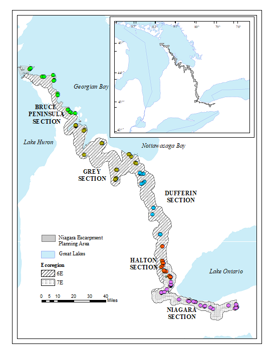
Resampling of the Niagara Escarpment Biosphere Reserve
Ontario Ministry of Natural Resources Science and Research Technical Report
D. Puric-Mladenovic1,2 and Y. Hayelom Araya2
1Ministry of Natural Resources and Forestry, 300 Water St., K9J 8M5, Peterborough, ON
2Faculty of Forestry, University of Toronto, 33 Willcocks St., M5S 3E8, Toronto, ON
The Niagara Escarpment is a provincially significant landform
and the
largest contiguous forested stretch in south-central Ontario. The
escarpment has
been subjected to a number of anthropogenic and environmental
stressors,
including land use and development, invasive species, agricultural
intensification, and climate change. 
To understand how forest composition, structure, and function have changed across the Niagara Escarpment since the late 1970s, a field sampling research project was initiated in 2011 to: 1) Re-inventory forest stands originally sampled from 1979 to 1981 using the Point-Quarter method to see whether changes in forest structure and composition were detectable; 2) Establish Vegetation Sampling Protocol (VSP) plots to link Niagara Escarpment forest monitoring with other landscape scale monitoring and planning efforts in southern Ontario. Besides detecting changes in forest composition and structure over the past three decades, the intent of the Niagara Escarpment re-inventory project was to demonstrate the importance and value of site level inventory and monitoring information as a baseline for conservation, management, and land use planning.
The re-sampling demonstrated that besides natural shifts and successional changes, there were some changes such as an increase in distribution and abundance of invasive plants, shade tolerant species, as well stand homogenization that might benefit from management attention. These results indicate that the use of forest cover alone, as proxy for conservation and planning decisions does not provide insight into forest quality and internal forest changes. Resource managers need to know where those changes are happening; what is causing the changes; whether the changes are positive or negative; and which issues to prioritize for management.
The results from both sampling methods indicate the importance and value of data collection and monitoring for assessing forest cover changes as well as evaluating and quantifying the existing state of natural forest cover on the Escarpment. However, while the point-quarter method demonstrated the value of monitoring natural cover in multifunctional landscapes such as the Niagara Escarpment, it was not initially designed as a monitoring protocol. VSP is an inventory and monitoring protocol based on geo-referenced fixed area sampling/ plots, whose stratified random design would capture the range of plant communities, environmental conditions, influences and variability. Furthermore, the protocol is easier to implement, re-sample and integrate with large-scale landscape analysis. The protocol’s broad-scale monitoring approach has diverse applications from detecting changes, informing management and conservation actions, to evaluating the effectiveness of land use policies and their applications.
- Ministry of Natural Resources and Forestry
- Niagara Escarpment Commission
- MacLean Foundation
- Niagara Escarpment Foundation
- Ontario Species at Risk Stewardship Fund
- Steve Varga, Aurora District, Ministry of Natural Resources and Forestry
- Judith Jones, Winter Spider Eco-Consulting
- Miranda Jones, Winter Spider Eco-Consulting
- Sally Robbins, Winter Spider Eco-Consulting
- Terry Carleton, Faculty of Forestry, University of Toronto
- Melissa Apostoli, Master of Science candidate, University of Toronto
- Lisa Grbinicek, Niagara Escarpment Commission
- Richard Murzin, Niagara Escarpment Biosphere Reserve
- John Riley, Member, Niagara Escarpment Commission Board of Directors
- Teri Trent, Biosphere Coordinator, Niagara Escarpment Biosphere Reserve
- Dan Ventresca, GIS Specialist, Niagara Escarpment Commission
- Steven Perks, Master of Forest Conservation (MFC) Student, Faculty of Forestry, University of Toronto
- Noah Borges, MFC Student, Faculty of Forestry, University of Toronto
- Emilie Metcalfe, Ministry of Natural Resources and Forestry
- David Tellier, Ministry of Natural Resources and Forestry Dave Nesbitt, Ministry of Natural Resources and Forestry
- David Bradley, Ministry of Natural Resources and Forestry
- Julia Buck, Ministry of Natural Resources and Forestry
- Kim Taylor, Ministry of Natural Resources and Forestry
- Silvia Strobl, Ministry of Natural Resources and Forestry
- Jim Mackenzie, Ministry of Natural Resources and Forestry