History of VSP
Plot based (fixed area) sampling originated as part of a PHD work of D. Puric-Mladenovic at the Faculty of Forestry, University of Toronto in 1998, when it was initially developed and used to sample forests in the Regional Municipality of York.The need for landscape based management and planning in support of various applications, and an absence of standardized, yet diverse vegetation inventories and mapping, have prompted the OMNR (former Southern Science and Information Section - SSIS) to embrace the further development of the Vegetation Sampling Protocol (VSP).
Over the years, the protocol has been further developed, enhanced, tested and applied as a collaborative effort between the OMNRF and the Faculty of Forestry, University of Toronto.
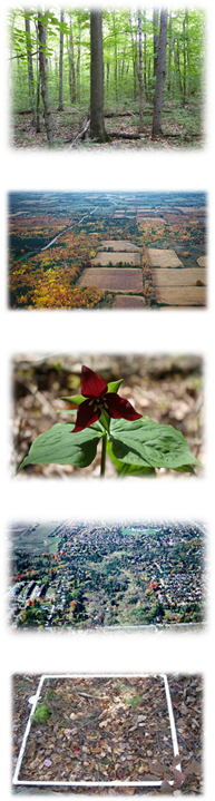
In 2005, VSP was used to support field inventory and data collection for predictive vegetation modeling (PVM) and mapping in forested areas. This collection took place in four study areas, including the St. Lawrence National Park Greater Park Ecosystem and Eco-district 6e10, Bruce Peninsula National Park and Ecodistrict 6e14, Kawartha Highlands Provincial Park, and Trent Severn Waterway.
This sampling initiative is described by Frank Burrows of Bruce National Park (2005) as "...an updated vegetation inventory and classification project and secondarily a soil/drainage inventory/classification. The sampling and mapping process that has been developed is similar to FRI mapping, but has a sampling regime and error assessment process that is more explicit and statistical. The final output is SOLRIS polygons (macropolygons), with different vegetation variables (i.e. structural, compositional) nested within".
While the initial focus of VSP was forest sampling,
 the protocol was modified further in 2006 to
accommodate and support wetland inventory and mapping. Following
two years of
forest and wetland sampling, in 2007 and 2008, VSP was enhanced
further to allow sampling of other natural (rock-barrens, shrub, open
canopy forest, successional, degraded) and anthropogenic communities.
Since 2009, the protocol has been further enhanced, tested and applied
to support vegetation monitoring, data collection for biomass and
carbon
estimates, invasive species monitoring and climate change monitoring.
the protocol was modified further in 2006 to
accommodate and support wetland inventory and mapping. Following
two years of
forest and wetland sampling, in 2007 and 2008, VSP was enhanced
further to allow sampling of other natural (rock-barrens, shrub, open
canopy forest, successional, degraded) and anthropogenic communities.
Since 2009, the protocol has been further enhanced, tested and applied
to support vegetation monitoring, data collection for biomass and
carbon
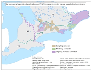
estimates, invasive species monitoring and climate change monitoring.Since 2011, VSP has been used to pilot and support monitoring of natural cover in the Lake Simcoe watershed (as part of the Lake Simcoe Protection Plan), Niagara Escarpment, City of Kitchener, City of Guelph and Rouge National Urban Park.
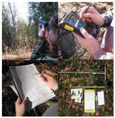
 VSP is
now capable of sampling any vegetation type,
whether natural, semi-natural,
anthropogenic, forest, wetland, or grassland in both urban and rural
areas. In addition, the spatial component of
the protocol and sampling design have been improved to meet
different mapping and inventory
/ sampling needs. For example, the protocol can be used for anything
from plot based sampling, to sampling outlined vegetation stands or
zones (i.e. vegetation polygons), to sampling vegetation along
transects.
VSP is
now capable of sampling any vegetation type,
whether natural, semi-natural,
anthropogenic, forest, wetland, or grassland in both urban and rural
areas. In addition, the spatial component of
the protocol and sampling design have been improved to meet
different mapping and inventory
/ sampling needs. For example, the protocol can be used for anything
from plot based sampling, to sampling outlined vegetation stands or
zones (i.e. vegetation polygons), to sampling vegetation along
transects.