VSP Sampling: Science & Research Projects
Urban Areas & Municipalities |
| City of Toronto |
| City of Kitchener: Natural Areas Inventory and Monitoring |
| City of Guelph: Natural Areas Monitoring and Emerald Ash Borer impact on Ash Population in Natural Areas |
| City of Mississauga |
| City of Cambridge |
Landscape Projects |
| Lake Simcoe Natural Cover Monitoring |
| Niagara Escarpment |
| Nature Conservancy of Canada Eastern Ontario |
| Ontario Nature Natural Cover Monitoring |
| Trent Severn Waterway |
Institutions, Properties and Parks |
| University of Waterloo Co-operative Education Program |
| Toronto Botanical Garden |
| rare Charitable Research Reserve |
| The Rouge National Urban Park Pilot Sampling |
| Sunnybrook Hospital |
| Camp Scugog |
| Private Landowners |
Indigenous Communities |
| Chippewas of Georgina Island First Nation |
| Alderville First Nation |
Municipalities |
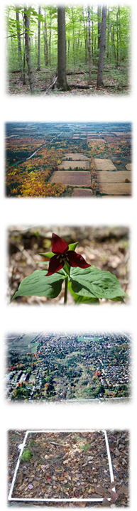
City of Toronto |
The City of Toronto
established 200 permanent terrestrial ecological monitoring plots in
2019 to collect data on the health of its ravines and natural areas,
advancing the implementation of the Toronto Ravine Strategy (2017). VSP data will support the City’s management, planning and policy needs (Ravine Strategy Implementation; City of Toronto 2020).
VSP sampling provided a baseline assessment of ecological condition and
benchmark upon which to measure changes over time in response to
management actions. Additional VSP sampling is planned for 2020 to
produce a more extensive network of monitoring plots within Toronto,
complementing existing data of the TRCA and integrating with the larger
sampling effort throughout southern Ontario.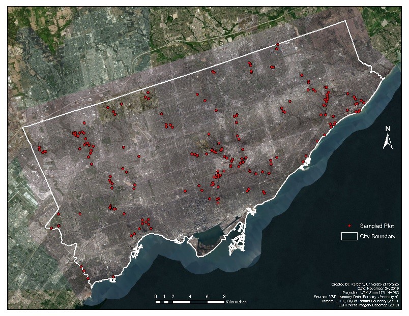 |
City of Kitchener: Natural Areas Inventory and Monitoring |
The City of
Kitchener maintains a total of 169 natural areas comprising
of
wetlands, woodlands,
meadows, and waterways. This amalgamation of natural areas possess
significant wildlife habitat and landforms that are recognized for
their ecological value. Due to severe urban pressures such as
development, invasive plant
and insect outbreaks, pollution, and recreation occurring in these
urban forests, it has become important to monitor the effects that
these threats are having on the City’s remaining forest communities. VSP was first undertaken in Kitchener in the summer of 2015. In collaboration with the Faculty of Forestry, University of Toronto and the Ontario Ministry of Natural Resources and Forestry, the City of Kitchener aims to utilize VSP’s diverse information on the composition and structure of its vegetation communities to improve their future management, land-use planning, and conservation actions. The 2015-16 field sampling enabled the collection of vegetation information throughout a number of parks and natural areas, as well as setting the stage for comprehensive monitoring of natural areas within the City. This research will provide valuable information to aid in the restoration of woodlands, wetlands and waterways that are being threatened by their urban surroundings. With the assistance of three MFC interns, the City has collected data on 16 of its natural areas. Field sampling in 2015 conducted by Master of Forest Conservation (MFC) students: Emma Thurston, Tania Ramkumar. Field sampling in 2016 was led and managed by Tania Ramkumar with assistance from a MFC intern Joe Scott. |
City of Guelph: Natural Areas Monitoring & Emerald Ash Borer Impact on Ash Population in Natural Areas. |
| VSP sampling was implemented in Guelph in summer 2016 as a
proactive response to monitoring natural areas and assessing the
impacts and risks
on natural areas due to Emerald Ash Borer (EAB) (Agrilus planipennis).
Forest monitoring, as a collaborative effort among
the City
of Guelph, OMNRF
and University
of Toronto Faculty of Forestry, is envisioned to provide data
that supports
research but also informs landscape planning, forest management
activities, invasive
species management, restoration efforts, protection and recovery of
species at
risk and their habitats.
Native Ash trees, found in a wide variety of forest and habitat types, are vital to Guelph’s natural areas and urban forests. Thus VSP sampling 2016 targeted stands with a significant component of Ash. The sampling has provided critical, baseline information to quantify the existing and potential loss of Ash associated with EAB. In addition, data collected enabled the impact of Ash loss on forest composition, structure and function to be assessed. EAB, a wood boring beetle, was first detected in Guelph in 2011 and has since affected most if not all of the region’s Ash trees. 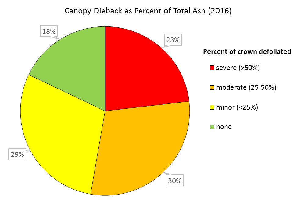 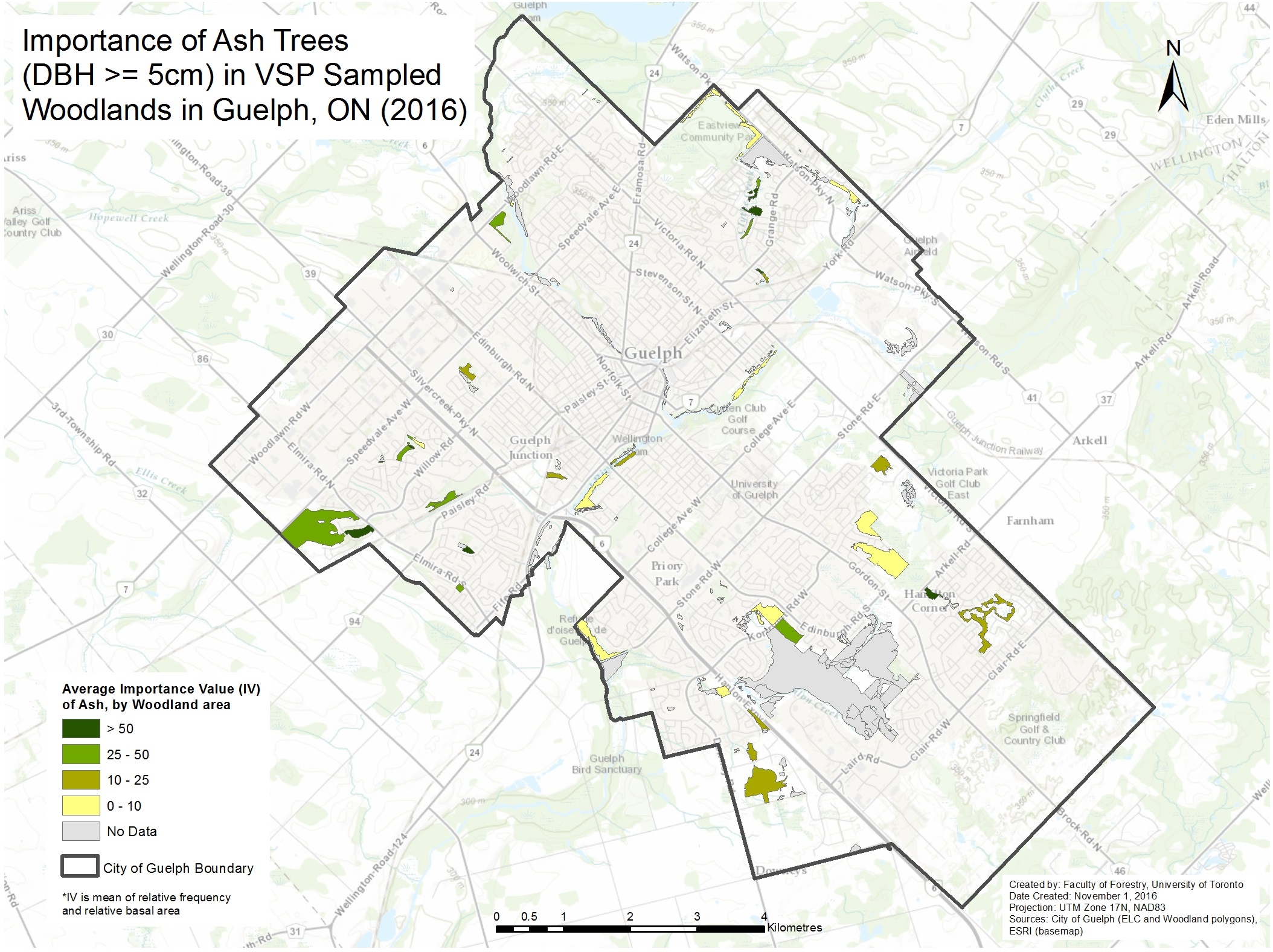 |
City of Mississauga |
|
The City of Mississauga initiated woodland monitoring using VSP in 2018 and 2019. Sampling collected an initial inventory of vegetation within the City’s woodlots, including information on regeneration, vegetation composition, tree height and diameter, deadwood, plot surface features, topography, hydrological indicators, and vegetation class. |
City of Cambridge |
|
The City of Cambridge applied VSP
to inventory priority woodlots within their natural parklands in 2017. As a
result of this work,
a management plan was developed for Victoria Park, a mature woodlot identified
as an “Environmentally Sensitive Policy Area”. This provided direction to help
the City meet its goals for the woodlot, which are: (1) to ensure the
ecological health of the woodlot including a mature, healthy, and native forest
species composition, and (2) to maintain facilities for passive recreational
use such as walking, running, and nature enjoyment. VSP inventories provided
quantitative measures of impacts from invasive species, poor recruitment of red
oak (Quercus rubra), and recreation pressures to inform management
actions. |
Landscape Projects |
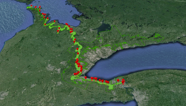
Lake Simcoe Natural Cover Monitoring |
| The Lake Simcoe Natural Cover Monitoring Project is a research project that is being undertaken as a partnership between the Faculty of Forestry, University of Toronto, the Ontario Ministry of Natural Resources (Science and Research Branch, and Southern Region - Aurora and Midhurst Offices) and the Ontario Ministry of Environment and Climate Change. Field sampling related to the project was piloted in 2011, and continued in 2014-2016. |
Niagara Escarpment |
 VSP
sampling was piloted on the Niagara Escarpment in 2011 and
2012.
As a result, over 130 plots were sampled across mature
forest stands previously sampled by Steve Varga (OMNRF) 30
years
ago. VSP plots were piloted to test monitoring applications
and a
comprehensive vegetation inventory, as well as to support
the diverse management, planning, and
conservation needs on
the escarpment. VSP
sampling was piloted on the Niagara Escarpment in 2011 and
2012.
As a result, over 130 plots were sampled across mature
forest stands previously sampled by Steve Varga (OMNRF) 30
years
ago. VSP plots were piloted to test monitoring applications
and a
comprehensive vegetation inventory, as well as to support
the diverse management, planning, and
conservation needs on
the escarpment.This research project is a collaborative effort between the Faculty of Forestry, University of Toronto, OMNRF - Science & Research Branch (Started with the former OMNR - Southern Science & Information Section), and the Niagara Escarpment Commision & Niagara Biosphere Reserve. |
Nature Conservancy of Canada Eastern Ontario |
| The Nature Conservancy of Canada (NCC) completes vegetation community inventory and classification using VSP on their portfolio of conserved spaces in eastern Ontario. This is part of the baseline inventory NCC carries out on new acquisitions. Once vegetation communities are classified, NCC uses this information to prepare a property management plan and recommend a suite of stewardship actions. One of the main applications of the classification is in the management of invasive species. |
Ontario Nature Natural Cover Monitoring |
Ontario
Nature protects wild species and wild spaces through
cons ervation,
education and public engagement. Ontario Nature is a
charitable organization representing more than 30,000 members and
supporters, and 150 member groups from across Ontario. ervation,
education and public engagement. Ontario Nature is a
charitable organization representing more than 30,000 members and
supporters, and 150 member groups from across Ontario. Ontario Nature has been protecting significant natural areas with its nature reserve system founded in 1961, preserving some of the province’s best remaining examples of imperiled and vulnerable habitats. Today, with 24 properties totalling 2,788 hectares, Ontario Nature is committed to protecting wild species and wild spaces through conservation, education and engagement. Ontario Nature uses Vegetation Sampling Protocol (VSP) to collect detailed information about key habitat features on each nature reserve to help to inform management practices and long-term monitoring goals. More information about Ontario Nature’s nature reserves can be found here Ontario Nature Citizen Science Initiatives: Ontario Nature’s largest citizen science project is the Ontario Reptile and Amphibian Atlas (ORAA). Led by Ontario Nature since 2009, the goal of the ORAA is to improve our knowledge of the distribution and abundance of Ontario’s reptiles and amphibians by engaging the public in reporting their sightings. Participants can also contribute by participating in annual monitoring programs, such as the Backyard Frog and Salamander Surveys as well as Vernal Pool Mapping. In 2016, Ontario Nature launched the Directory of Ontario Citizen Science (DOCS). DOCS is an online platform that connects seasoned and aspiring citizen scientists with volunteer opportunities across the province. This tool creates a centralized location where people can access information about citizen science programs across the province. |
Trent Severn Waterways |
| Details pending |
Institutions, Properties and Parks |
University of Waterloo Co-operative EducationProgram 2014, 2015 and 2016 |
| Summer 2014
Three groups of students carried out VSP field sampling in natural areas near Huntsville, Ontario between July and August 2014 as part of a four week long field course, ERS 341 and their summer Co-op program. The summer Co-op program provides students the unique opportunity to lead and complete real projects for community organizations while honing their skills as field ecologists. The University of Waterloo provides students with VSP training through the Waterloo Summit Centre for the Environment in Huntsville (also open to the public). Through this field training and Co-op program, students gain knowledge about how to conduct vegetation inventory and monitoring of settled landscapes, while collecting the field information and supporting VSP projects. Group 1: Justin Maddalena, Cheryl Reyes and Timmy Nassar used the VSP methodology to survey the Dyer  Memorial Nature
Reserve and Monument Site in Huntsville,
Ontario. This
site serves as an inactive cemetery and recreational area for
the town of
Huntsville under the
ownership of the Muskoka Conservancy. The reserve
encompasses approximately
3 kilometres of
the Big
East River shoreline, a mix of deciduous andvspsupports.html
coniferous forests, and
an oxbow pond that provides
habitat for
amphibians and other wetland plants and animals. The property has been
certified as
“Ecologically
Sensitive” and property management focuses on conservation
and
landscape management with the help of volunteers to help
protect
and build heritage for future generations. Memorial Nature
Reserve and Monument Site in Huntsville,
Ontario. This
site serves as an inactive cemetery and recreational area for
the town of
Huntsville under the
ownership of the Muskoka Conservancy. The reserve
encompasses approximately
3 kilometres of
the Big
East River shoreline, a mix of deciduous andvspsupports.html
coniferous forests, and
an oxbow pond that provides
habitat for
amphibians and other wetland plants and animals. The property has been
certified as
“Ecologically
Sensitive” and property management focuses on conservation
and
landscape management with the help of volunteers to help
protect
and build heritage for future generations. Group 2: Kyle Wang and Angela Zhou used the VSP methodology  to
survey
the
Nelson Head Nature Reserve in
Huntsville, Ontario. This 9 acre nature reserve,
owned by the Muskoka Conservancy, has gently rolling terrain with
mature trees, a stream and exposed bedrock. The
nature reserve is in an urban area
surrounded by residential development and supports several vegetation
communities including forest areas with a mix of tolerant and
mid-tolerant trees, an herbaceous open area (an old homestead
site) and recently planted sites which contain young tree species. The
property also contains a fern grotto and Marsh Marigold at its northern
limit. to
survey
the
Nelson Head Nature Reserve in
Huntsville, Ontario. This 9 acre nature reserve,
owned by the Muskoka Conservancy, has gently rolling terrain with
mature trees, a stream and exposed bedrock. The
nature reserve is in an urban area
surrounded by residential development and supports several vegetation
communities including forest areas with a mix of tolerant and
mid-tolerant trees, an herbaceous open area (an old homestead
site) and recently planted sites which contain young tree species. The
property also contains a fern grotto and Marsh Marigold at its northern
limit. Group
3: Ian Blainey, Carly
Van Daele, Cassandra Weins and Jessica Williamson carried out VSP
sampling on a 1000 acre private property on Pond Meadows Road, just off
of Brunel Road, in Huntsville, Ontario.
The forest on this property is characterized by a mix of deciduous and
coniferous trees on the Precambrian Shield, including sugar maple, red
maple, black cherry, yellow birch, basswood, balsam fir and white pine.
The site also contains some lake ecosystems and trails. There are sandy
soils on the property which is typical of the area where soils are
unproductive and have low buffering capacity and lay on top of various
gneisses. Group
3: Ian Blainey, Carly
Van Daele, Cassandra Weins and Jessica Williamson carried out VSP
sampling on a 1000 acre private property on Pond Meadows Road, just off
of Brunel Road, in Huntsville, Ontario.
The forest on this property is characterized by a mix of deciduous and
coniferous trees on the Precambrian Shield, including sugar maple, red
maple, black cherry, yellow birch, basswood, balsam fir and white pine.
The site also contains some lake ecosystems and trails. There are sandy
soils on the property which is typical of the area where soils are
unproductive and have low buffering capacity and lay on top of various
gneisses. |
Toronto Botanical Garden |
| The Toronto Botanical Garden (TBG) will be expanding its footprint to manage and restore Wilket Creek ravine within Edwards Gardens, as described in the City of Toronto’s Edwards Gardens and TBG Master Plan & Management Plan. VSP will be applied across the ravine’s natural areas to derive baseline site information to assess ecological health and provide a benchmark upon which to measure the success of restoration efforts. Plots will be marked and resampled to measure changes in vegetation composition, structure, and function over time to support adaptive management and research. |
rare Charitable Research Reserve |
| rare Charitable Research Reserve initiated VSP monitoring in 2018 within its protected natural areas. A report summarizing the application of VSP at rare, initially targeting Hogsback and Thompson Tract, demonstrated VSP as an “extremely valuable protocol to add to rare’s long-term monitoring program”. Sampling efforts identified species new to the property’s plant list and provided high-quality data to support land management work and prioritize sites for invasive species removal and restoration. Rare has developed a complete network of plots throughout the remainder of its property, which will be sampled over time and revisited to track changes. |
The Rouge National Urban Park Pilot Sampling |
 In
collaboration with Parks Canada, VSP pilot sampling in the
Park was conducted in 2015 by two Master
of Forest Conservation students:
Suzanne Perry
and Emma
Bowley. This project enables
information about vegetation communities throughout the park to be
collected, exploring its applications to vegetation management and
comprehensive
vegetation monitoring. The modular nature of VSP is adaptable to a wide
range of vegetation communities and management objectives, and as such
enabled a multitude of vegetation and habitat measures
to be collected in 2015. Sampling was also conducted during summer 2016. In
collaboration with Parks Canada, VSP pilot sampling in the
Park was conducted in 2015 by two Master
of Forest Conservation students:
Suzanne Perry
and Emma
Bowley. This project enables
information about vegetation communities throughout the park to be
collected, exploring its applications to vegetation management and
comprehensive
vegetation monitoring. The modular nature of VSP is adaptable to a wide
range of vegetation communities and management objectives, and as such
enabled a multitude of vegetation and habitat measures
to be collected in 2015. Sampling was also conducted during summer 2016. |
Sunnybrook Hospital |
| Sunnybrook Hospital applied VSP in its forested lands in 2018. The natural ravines and trees nearby the hospital are recognized for providing numerous health benefits, prompting new initiatives to inventory and protect these natural features at Sunnybrook. The natural areas inventory data also contributes data to the broader network of plots established by the City of Toronto, including in neighbouring Sunnybrook Park. |
Camp Scugog |
| Camp Scugog conducted VSP inventories of their property located on Lake Scugog in northeast Durham in 2018. Sampling was completed by an MFC intern with assistance from campers. Findings suggested that trails on the property and foot traffic were facilitating the spread of invasive species. Recommendations from the resulting report included establishing an annual monitoring strategy for invasive species, beginning invasive species removal, and incorporating environmental management of the Camp Scugog property into everyday camp activities. |
Private Land |
| VSP has also been implemented on private lands in southern Ontario. Private landowners such as the Master Family have applied VSP to guide their land management decisions towards enhanced biodiversity and restoration of old growth characteristics of their property (380 ha woodlot) in Lanark Highlands near Flower Station, Ontario. |
Indigenous Groups |
Chippewas of Georgina Island First Nations |
VSP
sampling on Georgina Island was a partnership project among the Chippewas of Georgina Island
First Nation Island, the Lake Simcoe Region Conservation Authority, the Faculty of Forestry,
University of Toronto, and the Ontario Ministry of Natural Resources (Science and
Research Branch, and Southern Region - Aurora and Midhurst 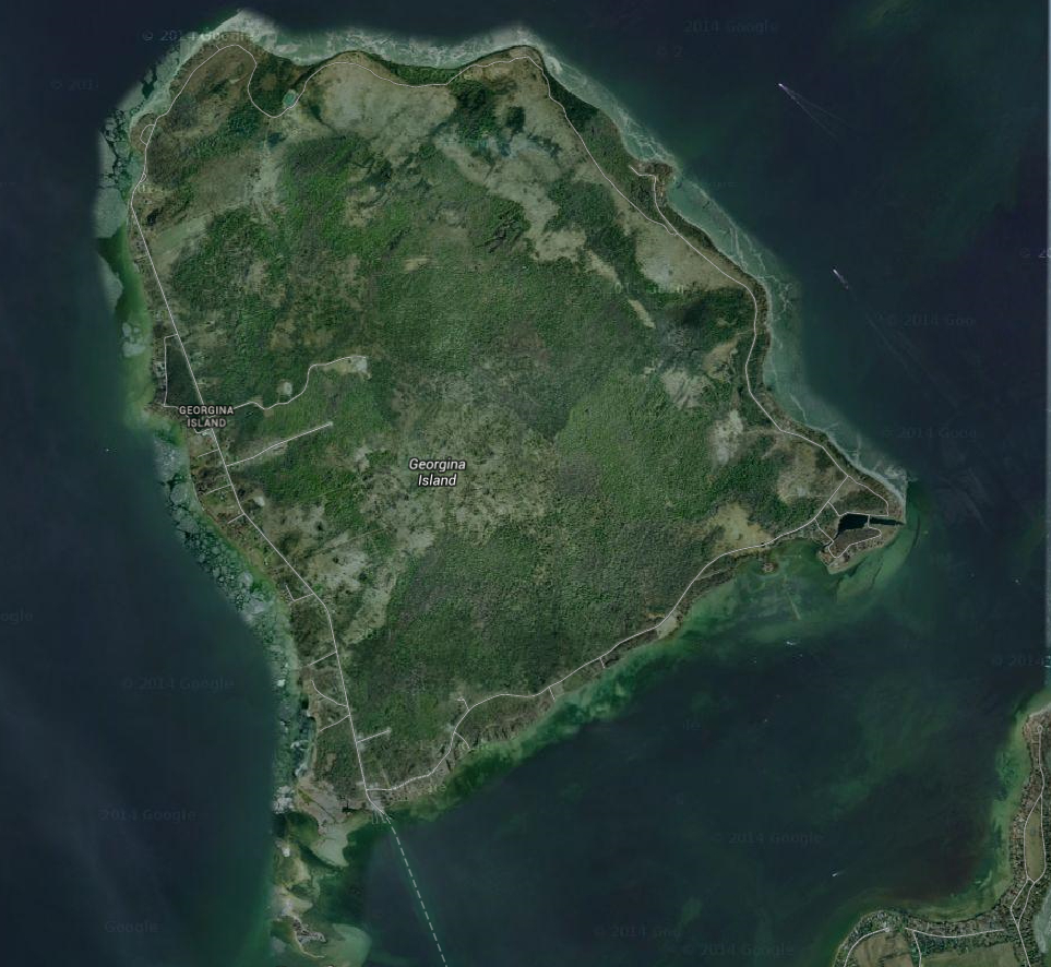 Offices). A set
of VSP plots were sampled on Georgina Island during the summer of 2014. Field
data was collected between July and August 2014 by a University of Toronto
Masters student (Gilles Pansin) and a Georgina Island First Nation summer
student (Stephen Porte). A subset of VSP plots was selected from a sampling VSP
grid that covered the Lake Simcoe watershed and Georgina Island. The VSP field data
was tested for its diverse applications to: subwatershed planning, monitoring
and planning for climate change and adaptation, natural cover monitoring as
part of the Lake Simcoe Protection Plan, science and research, quantitatively
characterizing vegetation communities on the islands, quantitatively describing
wildlife and species at risk habitats, and establishing a baseline condition
for long-term monitoring. In 2017, additional field sampling was conducted by Georgina
Island First Nation students and U of T field crews. Offices). A set
of VSP plots were sampled on Georgina Island during the summer of 2014. Field
data was collected between July and August 2014 by a University of Toronto
Masters student (Gilles Pansin) and a Georgina Island First Nation summer
student (Stephen Porte). A subset of VSP plots was selected from a sampling VSP
grid that covered the Lake Simcoe watershed and Georgina Island. The VSP field data
was tested for its diverse applications to: subwatershed planning, monitoring
and planning for climate change and adaptation, natural cover monitoring as
part of the Lake Simcoe Protection Plan, science and research, quantitatively
characterizing vegetation communities on the islands, quantitatively describing
wildlife and species at risk habitats, and establishing a baseline condition
for long-term monitoring. In 2017, additional field sampling was conducted by Georgina
Island First Nation students and U of T field crews.
|
Alderville First Nation |
| Alderville First Nation initiated VSP inventories of rare Alderville Black Oak Savanna habitat in 2019. Ecological restoration within the area includes prescribed burning, planting native species, and invasive species control, guided by scientific research and long-term monitoring to maintain valuable native prairie and savanna habitat. |