First, choose the allometric formula (above) that you want to view, then choose the desired product from the right.
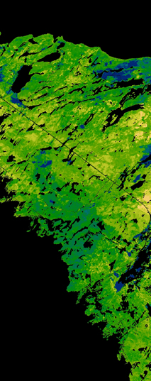
Predicted Forest Biomass and Carbon for Bruce Peninsula - Eco-District 6E-14, Ontario
Welcome to the interactive viewer for Predicted Forest Biomass and Carbon on the Bruce Peninsula. To begin using the viewer, select one of three allometric formulas from the top menu then select the map product you wish to view. From within each view, you may view a JPG of the data, download a PDF map of the data, or download a zipped copy of the actual GRID for use within a GIS.
The forest biomass predictions were created using three separate allometric formulas and a combination of field-collected tree measurements and other spatial data layers such as digital elevation models and derivatives, climate trends, and forest cover among others.
The large volume of geo-referenced vegetation data was collected during the summers of 2005-2007 through partnerships with practitioners. Statistical models of biomass were developed which were then extrapolated and mapped across the entire study area. The above-ground forest biomass data layer was the result of these extrapolations and all other data layers were derived from it according to the relevant literature. Root portions were considered to be 25% of the above-ground value and sequestered carbon was considered to be 47.5% of the biomass value, as per relevant literature.
For more information on the allometric formulas used refer to:
- Puric-Mladenovic, D., H. Morrison, S. Strobl. Allometric Formulas and methods for Biomass Estimates using Vegetation Sampling Protocol Data. 2009. Information Management and Spatial Analysis, Southern Science and Information Section, Ontario Ministry of Natural Resources.
- Jenkins, J. C., D. C. Chojnacky, et al. (2003). "National-Scale Biomass Estimators for United States Tree Species." Forest Science 49(1): 12-35.
- Jenkins, J. C., D. C. Chojnacky, et al. (2004). Comprehensive Database of Diameter-based Biomass Regressions for North American Tree Species. General Technical Report. Newtown Square, PA, USDA Forest Service: 48.
- Lambert, M.-C., C.-H. Ung, et al. (2005). "Canadian national tree aboveground biomass equations." Canadian Journal of Forest Research 35: 1996-2018.
- Ter-Mikaelian, M. T. and M. D. Korzukhin (1997). "Biomass equations for sixty-five North American tree species." Forest Ecology and Management 97: 1-24.
For more information on the field data and sampling protocol used see Vegetation Sampling Protocol
To reference the page:
Puric-Mladenovic, D. and Clark. G. 2010. Predictive modeling and
mapping of biomass and carbon for Eco-district 6e14. Faculty of
Forestry, University of Toronto.
http://www.forestry.utoronto.ca/SettledLandscapes/BruceBiomassExplorer/